Mundaring Weir
Visitor information
Please note: no fishing, marroning or contact with the water body is permitted at this dam.
Opening hours
November – April hours:
Every day until 6pm.
May – October hours:
Every day until 5pm.
While we aim to ensure our dam sites open by 8:30am each day, opening hours may vary. The dam may also be closed at times due to maintenance or extreme weather.
Please note that the toilets are locked when the dam closes each day.
For the latest information on opening times, or assistance during your visit to Mundaring Weir, please contact 13 13 75.
To stay up-to-date on bushfire warnings and other local emergencies, visit Emergency WA.
Things to do at Mundaring Weir
![]()
![]()
![]()
![]()
Map of the facilities

Pack a picnic lunch
Enjoy an outdoor lunch or barbecue at one of the many beautiful picnic spots at Mundaring Weir. The kids will love exploring the nature play area too!
Please note that the picnic areas can’t be booked and are only available on a first-come, first-served basis.
If you are planning a large gathering or event at the dam, you'll need to let us know in advance. Please contact our team on 13 13 75.
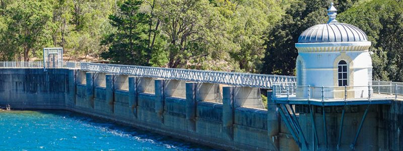
Look out over the dam and lake
There’s a walkway across the dam wall which provides stunning 360° views of the dam, Helena River, and C.Y. O’Connor Lake – a great spot for photos!
You can also look out from the viewing platform nearby the car park on the north side of the Weir.
Walk along the wildflowers and bush trails
Wildflower season is in full bloom from July to November, with a striking array of native flowers popping up around Mundaring Weir.
Stroll through the marked walking trails, where you can encounter many native bird species and wildlife.
Discover the history of Mundaring Weir
Visit the No 1 Pump Station to learn about the incredible early engineering feat of pumping water nearly 600km from Mundaring Weir to the Goldfields.
For up-to-date information on opening hours or to book a tour, please contact the National Trust of Western Australia, who manages the station.
Safety information
![]()
![]()
![]()
![]()
![]()
![]()
![]()
![]()
Please follow these simple rules to protect yourself and our water supply.
- Keep to the permitted pathways, roads, and recreational areas as shown by the signage.
- Don’t climb walls, fences, bridges, pipework, or other operational infrastructure.
- Keep emergency and operational access gates and roadways clear.
- Don’t operate taps, valves or controls.
Learn more about how we work to manage water quality.
Location and directions
Mundaring Weir is located in the Darling Scarp, just under an hour’s drive from the Perth CBD.
Follow the directions below to the Weir or get directions from your location in Google Maps.
- From Perth, take Guildford Road or Great Eastern Highway to Midland.
- Follow the Great Eastern Highway for approximately 16km towards Mundaring.
- Turn right into Nichol Street and follow the signs.


Dam wall
C.Y. O'Connor monument
Viewing platform
Planning your visit
There are numerous trails for hikers, history buffs, and nature lovers to explore at Mundaring Weir, including:
- The Weir Walk and O’Connor Trail. These two heritage trails are managed by the National Trust of Western Australia, and are marked with interpretive signage that tell the stories behind key landmarks and points of interest.
- The Bibbulmun Track. A section of this long-distance walking trail passes through Mundaring Weir and takes hikers through the surrounding bush area.
- The Munda Biddi Trail. This is an off-road cycling trail which runs through the bush on the northern side of the Weir.
- Bring enough food and water to stay hydrated while exploring the dam and its surrounds. Make sure to take all your rubbish with you.
- Be prepared for uneven ground or walking hazards by wearing comfortable and appropriate footwear.
- Bring a hat, sunglasses, and sunscreen to protect yourself from the sun.
- Don’t forget to bring your camera to capture the scenery!
There are accessible parking bays available at the C. Y. O'Connor Lake Lookout and the recreational area near the No 1 Pump Station.
Accessible toilets with ambulant cubicles and a baby change facility are also available in the No 1 Pump Station and near the Rose Garden.
Please see the map of the facilities for more accessibility information.